
Field Data Captured Without Repeated Site Visits
3D Laser Scanning and Modeling in Hopedale for accurate existing conditions documentation
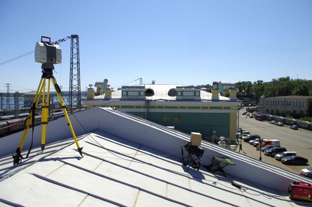
A. S. Elliott & Associates uses laser scanning technology to capture highly detailed measurements of buildings, structures, and sites across Hopedale and surrounding Massachusetts communities. The process records millions of spatial data points in a single session, producing comprehensive digital records that architects, engineers, contractors, and facility managers rely on when existing field conditions must be understood before design or renovation work begins. You avoid the delays and costs associated with incomplete measurements or assumptions about what's actually there.
Laser scanning measures complex geometries, structural elements, and site features by emitting rapid pulses of light and calculating distances based on reflection time, creating what's known as a point cloud. This data set becomes the foundation for accurate digital models used in renovation planning, clash detection, and documentation of existing conditions. When you're working with irregular surfaces, multi-level structures, or facilities where traditional measuring tools can't reach safely or efficiently, scanning delivers information that would otherwise require scaffolding, repeated visits, or educated guesses.
Schedule a consultation to discuss how scanning technology applies to your documentation or design needs.
Our Services
What Digital Models Reveal About Existing Structures
The point cloud generated during scanning translates into usable formats for design software, allowing your team to overlay proposed changes onto precise representations of what currently exists. Engineers reference these models to identify structural conflicts before fabrication begins, and contractors use them to verify field dimensions without waiting for on-site access. The digital model functions as a shared reference that reduces misunderstandings between disciplines and eliminates the need for return trips to measure elements that were missed during initial surveys.
Once A. S. Elliott & Associates completes the scan and processes the data, you receive deliverables formatted for your specific application, whether that's CAD drawings, Building Information Modeling integration, or visual point cloud files. You'll notice discrepancies between as-built conditions and original construction documents become visible immediately, allowing you to adjust design assumptions before they become field problems. Measurements are verified digitally rather than manually, and spatial relationships between building systems are documented in three dimensions rather than inferred from two-dimensional plans.
The service captures what's accessible during the scanning session, meaning areas behind walls, underground utilities, or obstructed zones require different investigative methods. Scanning works best when the site is accessible and lighting conditions allow the equipment to function without interference. Processing time depends on project size and the level of detail required in the final deliverable, but the field data collection itself happens in a fraction of the time traditional measuring would require for the same volume of information.
Questions About Scanning and Digital Documentation
The following addresses common concerns about how scanning technology applies to documentation and design projects in Massachusetts.
What types of projects benefit most from laser scanning?
Renovation projects involving complex existing structures, facilities with limited access windows, historic buildings where measurements must be non-invasive, and sites where traditional surveying methods can't safely document conditions all see significant advantages from scanning technology.
How accurate are the measurements from a laser scan?
Modern scanning equipment captures measurements with millimeter-level precision, producing point clouds where each data point represents a verified spatial coordinate. The accuracy depends on equipment calibration, environmental conditions during capture, and the distance between the scanner and the target surface.
When should scanning happen during a project timeline?
Scanning typically occurs after preliminary site evaluation but before detailed design work begins, allowing the digital model to inform design decisions rather than forcing retrofits after drawings are complete.
What deliverables do you receive after scanning is complete?
Deliverables vary based on project needs but commonly include registered point cloud files, two-dimensional CAD drawings extracted from the scan data, three-dimensional mesh models, and integration-ready files for BIM software platforms.
How does scanning reduce the need for field revisits in Hopedale and nearby areas?
Because the scan captures comprehensive spatial data in a single session, design teams reference the digital model to answer measurement questions that would otherwise require additional site visits, cutting down on travel time and access coordination for projects across Worcester County.
A. S. Elliott & Associates tailors scanning services to the documentation requirements of your specific project, whether that involves a single building or a multi-structure facility. Request an estimate to review how digital models support your design, renovation, or facility management objectives.